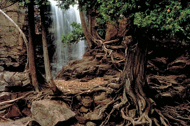
Gooseberry Falls State Park One of the most popular state parks in Minnesota.
Gooseberry Falls State Park
3206 Highway 61 East Two Harbors, MN 55616
Gooseberry Falls is the gateway to the North Shore. It is known for its spectacular waterfalls, river gorge, Lake Superior shoreline, Civilian Conservation Corps log and stone structures, and north woods wildlife.
Listen to the thunderous roar of the Upper, Middle and Lower Falls of the Gooseberry River as it plummets through a rocky gorge. Watch for waves, ships, or the moon rise on Lake Superior from an ancient lava flow known as the Picnic Flow.
Hike or ski to see the Fifth Falls through a forest of evergreens, aspen, and birch, and enjoy camping in modern campsites, picnicking, and relaxing along the Lake Superior shoreline or the Gooseberry River.
To get the most out of your visit, stop by the Joseph N. Alexander Visitor Center where you can find park information, interpretive displays, a park video, Nature Store, and more. Don’t miss the Gateway Plaza for outdoor interpretive signs on area resources and history.
- Historic CCC Log & Stone Structure
- Cross-Country Skiing
- Scenic Waterfalls
- Multi-Use Trails
- Visitor Center & Nature Store
- Year-Round Naturalist
- Gateway Plaza
- Bike Trail
Quick stats
1,682 acres
630,269 annual visits
32,384 overnight visits
Naturalist
Naturalist programs and activities are offered weekly from Memorial Day – Labor Day and on a limited basis at other times. Topics include area resources such as plants, animals, geology, Lake Superior, history, recreation, and more. Be sure to stop by the visitor center and outdoor Gateway Plaza to view interpretive displays and signs.
Wildlife
The park has recorded over 225 species of birds that nest or visit the park, 46 species of mammals, and ten species of reptiles and amphibians. Of special interest to visitors are white-tailed deer, black bears, gray wolves, pine martens, migratory Lake Superior salmon and trout, a variety of conifer-dependent birds, ravens, and the herring gulls that establish nesting colonies along the lakeshore. During fall and spring, many migratory birds can be seen because the park is along the North Shore flyway.
History
The area known as Gooseberry Falls State Park is intricately tied to human use of Lake Superior. At different times, the Cree, the Dakotah, and the Ojibwe lived along the North Shore. As early as 1670, the Gooseberry River appeared on explorer maps. The river was either named after the French explorer Sieur des Groseilliers or after the Anishinabe Indian name, Shab-on-im-i-kan-i-sibi; when translated, both refer to gooseberries. In the 1870s, commercial and sport fishermen began to use this area.
By the 1890s, logging became the principle use of the land around the Gooseberry River. In 1900, the Nestor Logging Company built its headquarters at the river mouth and a railway was used to carry the pine to the lake for rafting to the sawmills. Because of fires and intensive logging pressures, the pine disappeared by the early 1920s.
With the rise of North Shore tourism in the 1920s, there was a concern that the highly scenic North Shore would be accessible only to the rich. As a result the Legislature authorized preservation of the area around Gooseberry Falls in 1933. The following year, the Civilian Conservation Corps (CCC) began to develop the park. CCC crews built the park’s stone and log buildings and the 300-foot long “Castle in the Park” stone retaining wall. They also laid out the original campground, picnic grounds and trails. The area officially became Gooseberry Falls State Park in 1937. The CCC camps closed in 1941, but the park’s CCC legacy lives on. Designed with ties to the CCC, a new visitor center/wayside rest and Highway 61 bridge was opened in 1996.
Geology
Geologists have determined that about 1.1 billion years ago, the Earth’s crust began to split apart along a great rift zone now covered by Lake Superior. Huge volumes of lava flowed out onto the surface and cooled to form volcanic bedrock, mainly the dark type known as basalt. Several lava flows can be seen at the Upper, Middle, and Lower Falls and south of the Gooseberry River along the Lake Superior shore. The rifting also caused the flows to tilt gently toward the lake. These basalt lava flows, all along the North Shore, are also the birthplaces of Lake Superior agates.
About two million years ago, the Great Ice Age began as periodic glaciers (up to a mile thick) advanced into the region from the north. As they ground across the area, they changed the landscape dramatically, especially by excavating the whole basin now occupied by Lake Superior. About 10,000 years ago the last glacier melted back, allowing the basin to fill with water and starting the erosional process that creates the river gorges and waterfalls. Today, water, wind, and weather continue to shape the North Shore.
Landscape
Rocky Lake Superior shoreline, five waterfalls, Gooseberry River and gorge, Agate Beach and the Picnic Flow highlight the park. Trails lead through a fairly diverse vegetative cover of mixed evergreen, aspen and birch forests that provide habitat for a variety of birds, plants and other animals. Because the local climate is moderated by Lake Superior, some disjunct populations of arctic-alpine plants can be found in the park.
Phone Number (218) 834-3855
Park Site Campsite Reservations
All content the property of Gooseberry Falls State Park and MN DNR.


