The Mystery of the North Shore Salt Water
The Mystery of the North Shore Salt Water
Grand Marais, MN
By Sharon Moen
“We have running water,” jokes Michael Monroe of Hovland, MN. “I run and get it.”
With Lake Superior and ten percent of the world’s fresh surface water just yards away, it seems farcical that Monroe and Deb Mueller fetch water with plastic containers and muscle. They and many of their North Shore neighbors are in something of a pickle, living in a place where the ground water can be saltier than the sea. “Hyper-saline water is no shock at the bottom of a copper mine a kilometer underground,” said John Swenson, assistant professor of geological sciences at the University of Minnesota Duluth. “What’s surprising is to find water with such chemistry coming out of a household spigot.” This salty predicament is sporadic around the fringes of Lake Superior’s western lobe; drinkable water can come from a well 100 feet away from one that might have a chloride concentration greater than 40,000 parts per million (35,000 ppm is typical for ocean water).
It’s ironic that potable water is not a sure bet around Western Lake Superior. It’s intriguing that nobody really knows why. Several scientists and well drillers are willing to speculate and a Sea Grant staffer offers suggestions for afflicted well-owners… Read more! Click Below.
Beyond Salt – North Shore Water
The calcium chloride bite of some North Shore well water makes it tough to drink, but it’s the elevated levels of fluoride and boron leached from the bedrock that could affect your health.
Fluoride: too much or too little can damage teeth and bones. Duluth public water supplies are fluoridated to 1.2 parts per million (ppm). Groundwater along the North Shore can range from 0.4 to 14 ppm, sometimes within several hundred feet. About half of the wells in this region appear to fall within an optimal range (0.7-2.0 ppm).
Boron: high doses damaged reproduction and fetuses in study animals. The Minnesota Department of Health suggests drinking other water when concentrations exceed 0.6 ppm (level may be raised to 1 ppm within the next year). Groundwater along the North Shore can range from virtually zero to 5.4 ppm. Most wells in this region appear to be within recommended guidelines.
If you want your well water tested, contact a certified laboratory.
Reason For Water Mystery
Tipping suggests that something much older than the ice sheet – the Midcontinent Rift System – can alone account for the salty water rimming Western Lake Superior. The Midcontinent Rift System is a billion-year old tear that nearly severed North America and made a new ocean. It stretches through the Lake Superior Basin to Southern Kansas and is possibly related to a fracture in the Earth’s crust extending across Michigan and into Ohio. The basaltic lavas and reddish sedimentary rocks exposed along Superior’s shore from Canada through Duluth and around Michigan’s Keweenaw Peninsula are products of the Midcontinent Rift.
“When you poke a hole through the basalt, you encounter the thick reddish interflow layer that dips off under the lake,” said Tipping. “The water in this layer of clay, sandstone and siltstone has been out of contact with the modern world. Towards the top of the interflow, you’re more apt to find good water since the denser salt water sinks.”
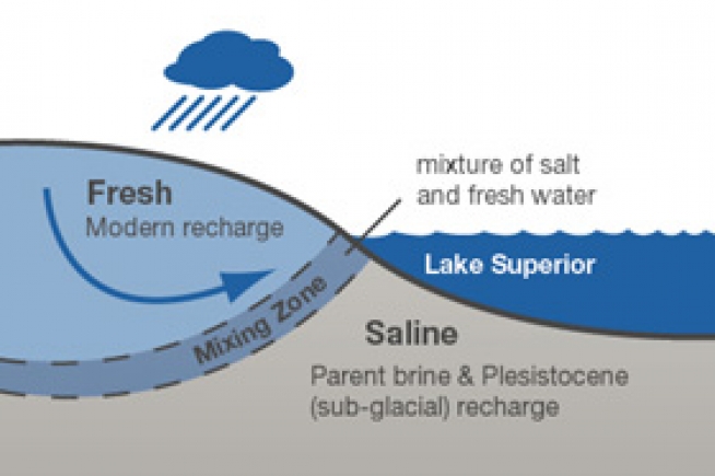
“It’s like a lens of fresh water floats on top of the salt water,” agrees Swenson, who thinks the brine harkens back to the rift system but believes a fluid-impelling mechanism, like the pressure from a glacier, is necessary to drive those deep dense brines skywards. He suggests the fresh water lens is thinnest near the lakeshore.
Content the property of Sharon Moen. Found through Minnesota Sea Grant Website.


